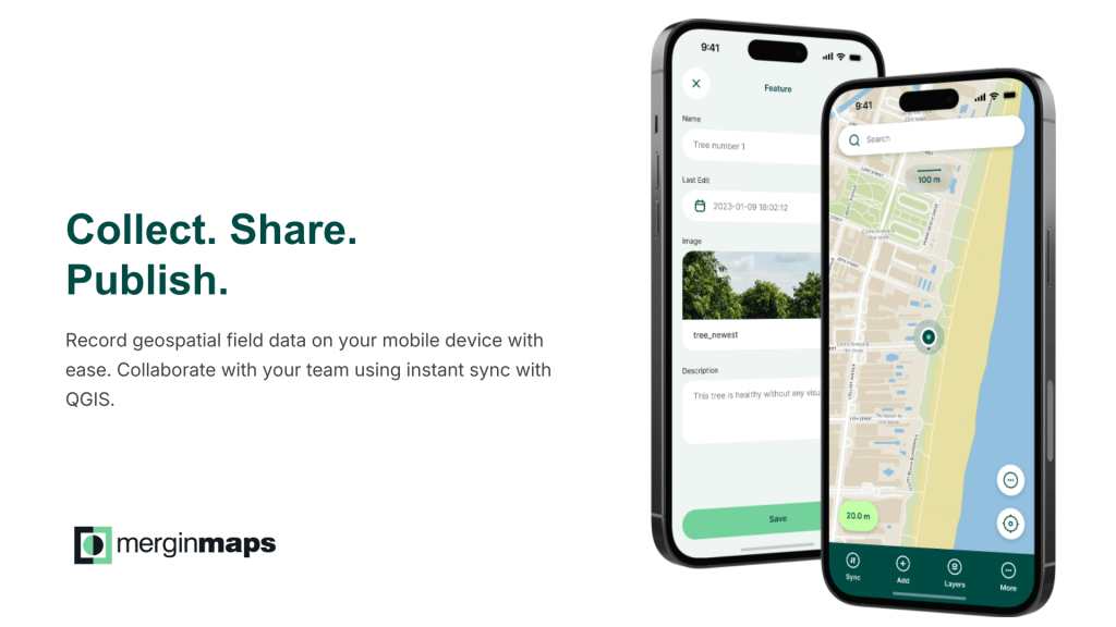
What is MerginMaps?
MerginMaps is a professional field data collection platform with projects managed and configured with QGIS, the world’s leading open-source GIS. It enables GIS officers and field staff to capture, edit, and synchronise spatial data directly from their mobile devices, working seamlessly within the same QGIS environment your team already uses in the office.
How Mergin Maps Works
MerginMaps bridges the gap between desktop GIS and fieldwork. Staff can take their QGIS projects into the field, collect and edit features against your existing spatial layers, and synchronise changes back to the office, all without leaving the QGIS ecosystem.
How Organisations Are Using Mergin Maps
Councils and government agencies are using MerginMaps across a wide range of spatial workflows. From mapping invasive weeds and monitoring vegetation, surveying public green and blue-green infrastructure, monitoring the safety and condition of public spaces, conducting environmental field surveys, capturing waste sampling data, to supporting wildfire prevention and emergency preparedness. If your team collects or maintains spatial data in the field, MerginMaps provides a purpose-built tool to do it reliably and efficiently. To see how organisations are using Mergin Maps in real-world field workflows, view the case studies here.
Australian Data Residency
For Australian government agencies, data sovereignty is not a matter of preference, it is a compliance requirement. Federal and state data governance frameworks prohibit sensitive public sector data from being stored outside Australia, and the consequences of non-compliance extend beyond IT policy to community trust and organisational accountability.
A default MerginMaps subscription stores your spatial data on servers in Europe, rendering your organisation non-compliant from the moment you sign up. For many Australian local government agencies, this is simply not an option.
We host MerginMaps on Australian cloud infrastructure, ensuring that your spatial data never leaves the country. All data is stored and processed within Australia, giving your organisation the confidence that comes with clear, verifiable data sovereignty, and keeping you on the right side of your compliance obligations from day one.
Integrated with Pozi
MerginMaps and Pozi work together as part of a connected spatial data workflow. Chartis Technology provides the tools to bridge the two platforms, including a command line interface to connect to your MerginMaps project and extract data, and integration support for FME to transform and load field-collected data into your Pozi environment.
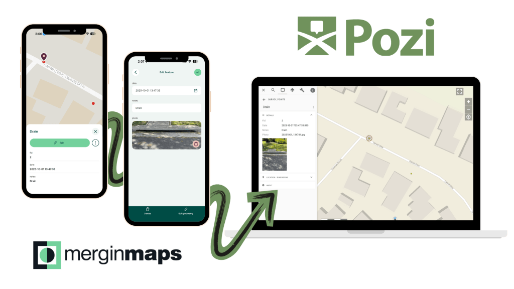
This means that spatial data captured in the field doesn’t sit in isolation, it can be processed, validated, and made available through Pozi to the broader organisation, where it can be visualised, queried, and shared across teams.
Together, Pozi and MerginMaps provide a complete spatial data workflow, from field capture to organisational visibility, without the complexity or cost of enterprise GIS software.
Why Chartis Technology?
Chartis Technology is an Australian company that understands the unique obligations councils and other organisations carry around data governance, procurement and community trust. When you work with us, you are not navigating a vendor’s global support queue, you are working with a local team that knows your context and is accountable to your outcomes.
- Australian data residency: your spatial data is hosted on Australian cloud infrastructure and never stored overseas.
- Local government expertise: we work extensively in the local government sector and understand your GIS, IT, and governance requirements.
- Integrated support: one point of contact for both MerginMaps and Pozi, simplifying vendor management and support.
Get Started
To find out how MerginMaps can support your spatial data workflows, get in touch with our sales team.